
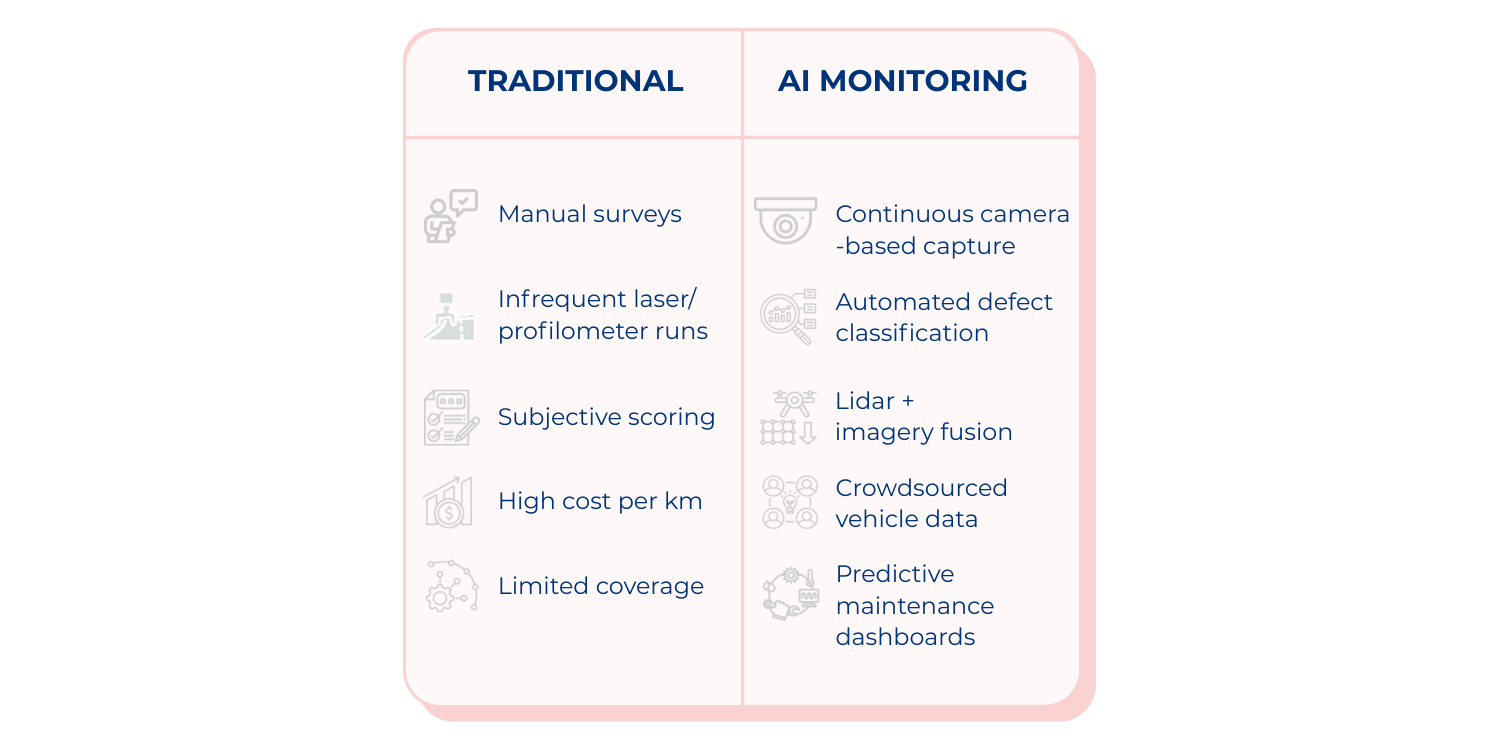
Highways are essential to economic growth, trade, and connectivity. Yet, ensuring their safety and resilience remains one of the toughest challenges for governments and road operators. Traditionally, monitoring road conditions has relied on manual inspections, visual surveys, and specialized vehicles equipped with laser or profilometer systems. These methods, while useful, are costly, infrequent, and often subjective. In a world where infrastructure demands are expanding and budgets are under constant pressure, the industry needs smarter, more efficient, and more objective tools to keep roads safe and reliable.
Over the last decade, the integration of Artificial Intelligence (AI), computer vision, and sensor-based monitoring systems has begun to transform how road assets are inspected and maintained. These technologies not only offer greater accuracy and frequency in data collection, but they also allow agencies to move from a reactive to a proactive approach, tackling risks before they escalate.
The persistent challenges
Despite ongoing investments, the industry still faces three recurring challenges. First, road inspections are often highly subjective. Inspectors might classify the same crack or pothole differently, which makes long-term benchmarking and decision-making unreliable. Second, surveys are typically infrequent. Dedicated laser profilometers or heavy monitoring vehicles are expensive, meaning they are deployed only once every year or two across large networks. This leaves agencies managing vast assets with outdated condition data. Third, budget pressures remain acute. Authorities must stretch limited resources across thousands of kilometers, forcing them to prioritize urgent repairs instead of preventive maintenance, which in turn drives up lifecycle costs (World Bank, 2022).

Emerging AI-driven solutions
AI-enabled monitoring technologies are reshaping how road networks are inspected, offering capabilities that directly tackle the longstanding challenges of subjectivity, infrequent data collection, and high operational costs. These technologies do not introduce incremental upgrades; they fundamentally reconfigure the monitoring paradigm by making assessments more objective, more frequent, and significantly more scalable. A range of complementary approaches, including computer vision, LiDAR, sensor fusion, and crowdsourced vehicle data, are now converging to provide a multi-layered understanding of road performance. Recent deployments in the United States (U.S.) show this multi-technology trend accelerating. Several DOTs (Department of Transportation) - Colorado, Utah, Georgia, Michigan - now combine AI image analytics, LiDAR, connected-vehicle data (C-V2X), and digital-twin simulation for predictive maintenance and traffic management. Pilots increasingly use automated “drone-in-a-box” systems for routine LiDAR and video inspections without field crews.
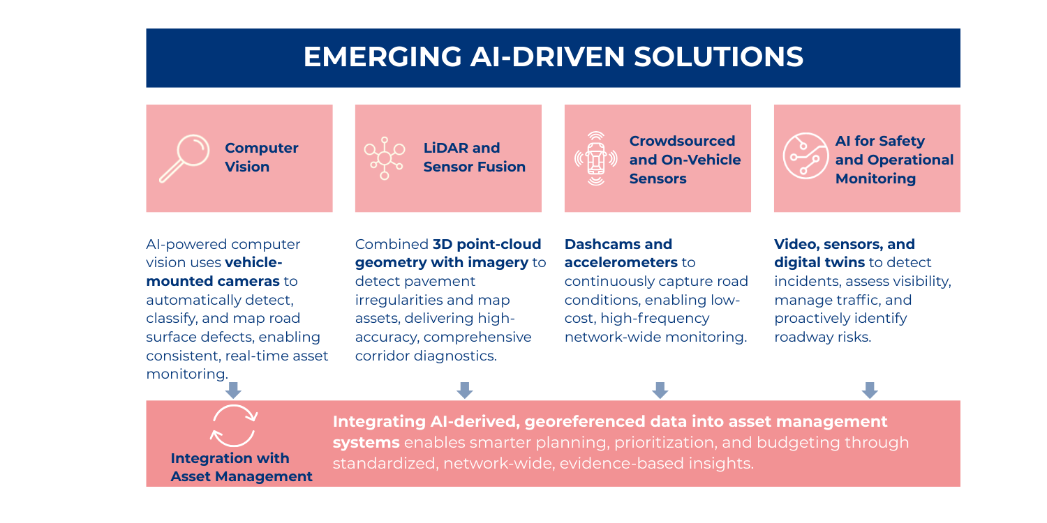
Computer vision
Computer vision stands out as one of the most widely deployed AI applications in road monitoring. The principle is straightforward but powerful: cameras mounted on moving vehicles capture continuous streams of roadway imagery, which AI models analyze to detect, classify, and quantify surface defects. Companies such as Applus+ IDIADA and Blyncsy have developed platforms capable of identifying cracks, potholes, rutting, and other pavement distresses with a level of consistency not achievable through manual inspections. The automation of defect classification significantly reduces human subjectivity and allows agencies to maintain uniform condition assessments across large, diverse regions.
A compelling example comes from Spain, where ASIMOB equips maintenance fleets with AI-enabled cameras that operate during routine activities, effectively turning everyday operations into full-scale condition surveys. Their system identifies a wide spectrum of defects, including longitudinal cracking, crocodile cracking, potholes, and surface deformation, and translates these observations into standardized indices comparable to international benchmarks like the International Roughness Index (IRI). The output is fully georeferenced and integrated into digital maps and asset management systems, providing a single, coherent data environment for planners and engineers (ASIMOB, 2023; EIT Urban Mobility, 2025).
Similar practices are emerging in the U.S., where Utah DOT, Ohio DOT, and Maryland DOT equip maintenance fleets with connected dashcams for continuous condition monitoring. Texas DOT and Caltrans also use AI incident-detection platforms (Iteris, Rekor, Miovision, NoTraffic) to extend computer-vision analytics into real-time safety and congestion management.
LiDAR and Sensor Fusion
While cameras reveal surface-level distresses, LiDAR brings an additional geometric dimension. Ouster and other providers offer digital LiDAR sensors capable of generating high-resolution 3D point clouds that capture both the pavement surface and roadside infrastructure. When LiDAR data is combined with AI analytics, the resulting model can detect subtle pavement irregularities, map crossfall and rut depth, and inventory roadside assets such as guardrails, barriers, signs, and lane markings. Importantly, LiDAR and computer vision are highly complementary: LiDAR provides superior geometric accuracy but is more complex and less practical for continuous, large-scale deployment, whereas camera-based detection offers lower geometric precision but enables continuous, low-cost, and scalable monitoring across entire networks. Fusing both modalities allows agencies to leverage the strengths of each, precision from LiDAR and high-frequency coverage from imagery, resulting in a richer, more robust understanding of corridor health (Ouster, 2024; National Highways, 2023).
LiDAR is also being deployed on automated drone missions. Alaska DOT, Caltrans, New York Thruway, and Utah DOT use BVLOS drone flights that capture LiDAR and optical data for bridges and elevated corridors, reducing lane closures and improving worker safety (NTT, 2024; MLIT/Metropolitan Expressway pilots, 2024–2025).
Crowdsourced and on-vehicle sensors
The most mature, scalable, and widely deployed road-monitoring technology in use today is image-based detection, powered by computer vision. Unlike specialized inspection vehicles or high-cost sensing suites, image capture can be performed through multiple ubiquitous channels: dashcams installed in ordinary vehicles, drones equipped with high-resolution cameras, and even standard smartphones acting as mobile inspection devices. This makes computer vision the most practical pathway for continuous, network-wide monitoring, enabling agencies to collect vast amounts of visual data with minimal incremental cost.
Building on this foundation of widespread image availability, the use of on-vehicle accelerometer data adds another dimension of insight. Instead of deploying dedicated survey fleets, agencies can analyze vibration readings generated naturally by passenger cars, buses, and service vehicles. Each time a vehicle travels over a road segment, onboard sensors record vertical acceleration that reflects surface roughness and, indirectly, pavement condition.
Vaisala is among the companies pioneering this approach, developing sensors that measure friction, slipperiness, and roughness in real time. Because thousands of vehicles drive the same routes daily, the resulting dataset is dense, dynamic, and far more up-to-date than a traditional survey cycle. ASIMOB uses a similar concept by aggregating anonymized accelerometer data and converting it into an “impact index”, which correlates strongly with established roughness metrics such as IRI (Vaisala, 2022; Vaisala, 2024; ASIMOB, 2023). This offers a low-cost pathway to near-continuous monitoring, especially on high-traffic corridors where data availability is naturally high.
AI for safety and operational monitoring
AI monitoring is no longer limited to pavement evaluation; agencies are increasingly using it to address broader operational and safety challenges.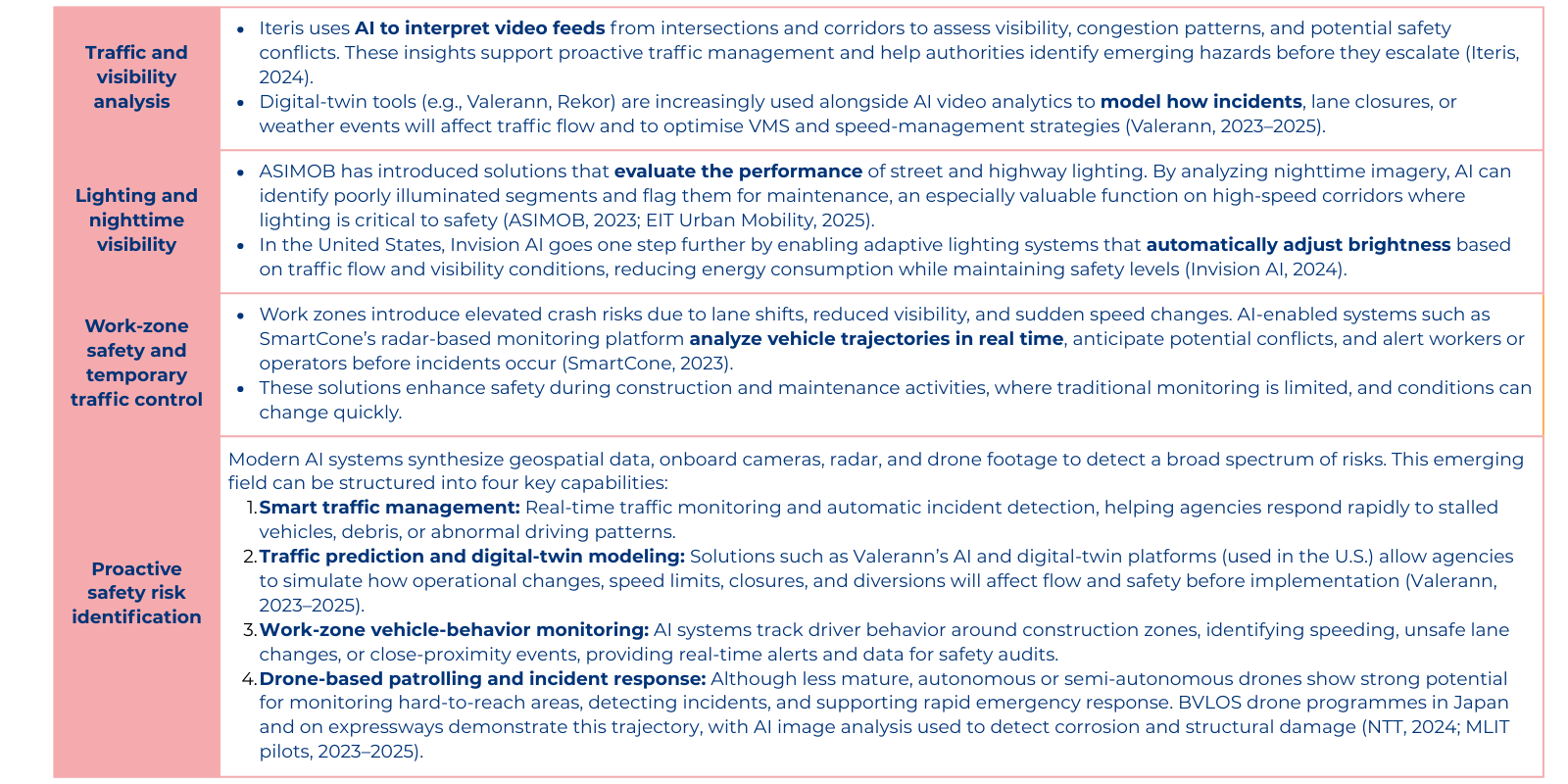
The result is a more comprehensive picture of road safety that incorporates infrastructure condition, traffic dynamics, and environmental context, and enables agencies to shift from reactive responses to proactive, data-driven safety management.
Integration with asset management
The greatest value of AI-driven monitoring emerges when these datasets are woven into broader asset management and budgeting frameworks. Standardized, georeferenced data from computer vision, LiDAR, and crowdsourcing can be fed directly into digital dashboards, enabling:
- Network-wide prioritization of interventions
- Multi-year pavement and asset management plans
- Regulatory reporting and audit trails
- Cost-benefit and lifecycle analyses
- Predictive deterioration modeling and risk-based planning
AI does not replace the judgment of engineers and asset managers; it strengthens the empirical foundation upon which their decisions rely. When integrated effectively, AI-powered monitoring becomes a cornerstone of modern infrastructure governance, improving transparency, optimizing maintenance budgets, and extending the life of road assets (World Bank, 2022; ISO 55000 / Digital Roads practice).
Additional considerations: governance, standards, and limitations
As road agencies embrace AI-enabled monitoring, the conversation is shifting from what the technology can do to how responsibly and effectively it can be deployed. The quality of insights produced by AI is increasingly critical for planning, budgeting, safety, and regulatory oversight. For this reason, the governance surrounding AI adoption becomes just as important as the algorithms themselves. Public authorities must navigate a series of considerations that go beyond technology procurement and touch on ethics, engineering standards, organizational readiness, and long-term stewardship.
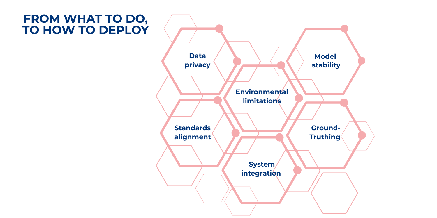
Data privacy and the ethical use of sensor data
AI systems inevitably generate and process large volumes of visual, positional, and sometimes audio data. Cameras mounted on vehicles, smartphones used for survey purposes, and fixed roadside sensors can all capture scenes that extend well beyond the pavement surface. As a result, privacy and ethical safeguards become foundational. Authorities must ensure that any identifiable information, such as faces, license plates, or private property, is anonymized or masked. Clear data retention policies, transparent public communication, and strict access controls are essential to maintaining public trust. Even when local regulations are less stringent than frameworks such as the GDPR, adhering to high international standards helps protect agencies from legal, ethical, and reputational risks.
Validation, calibration, and ground-truthing of AI models
AI-generated results are only as reliable as the systems used to train and validate them. While computer vision and sensor fusion technologies can dramatically improve consistency, they must be anchored to established engineering measurements. This requires calibration of AI outputs, such as crack severity or roughness indices, against certified equipment like profilometers, high-speed lasers, or ground-penetrating tools. Over time, periodic ground-truthing is essential to ensure that performance does not drift as weather changes, pavements age, and traffic patterns evolve. Agencies should also establish measurable performance indicators, including false-positive/false-negative rates, and consider independent third-party audits before using AI outputs in contractual or regulatory contexts. A standardized validation process ensures that the technology strengthens, rather than complicates, performance-based decision-making.
Alignment with engineering standards and asset management frameworks
For AI monitoring to be truly effective, its outputs must fit seamlessly into the engineering and asset management frameworks that agencies already use. Standards such as ISO 55000 (asset management), SHRP2 (pavement performance research), and European norms like EN 13108 and EN 12697 provide the backbone for consistency. National codes serve the same purpose. AI tools should therefore classify defects using familiar definitions and severity levels, and produce indices that map onto established specifications. This ensures comparability between AI-based assessments and traditional survey results, allowing agencies to integrate new technologies without overhauling their entire maintenance planning ecosystem.
Environmental and operational limitations
Despite their sophistication, AI tools are not immune to environmental constraints. Camera-based systems can struggle with glare, shadows, dust, or heavy rain; desert environments in particular pose challenges due to sand accumulation, harsh sun, and low visibility. Accelerometer-based roughness estimations are influenced by vehicle suspension systems, tire pressure, and speed variations. Even LiDAR performance can be affected by airborne particles or reflective surfaces. Recognizing these limitations is important, not because they diminish the value of AI, but because they underscore the need for well-defined operating protocols. Agencies may need to re-run inspections conducted in adverse conditions, apply confidence scoring to AI outputs, or use multimodal redundancies (e.g., combining vision, LiDAR, and accelerometers) to ensure reliability across all seasons and regions.
Interoperability and integration with legacy systems
Many road authorities operate with legacy GIS platforms, fragmented inventories, and multiple databases, some focused on pavements, others on drainage, signage, or structures. Introducing AI into this environment is not simply a matter of adding a new tool; it requires thoughtful integration. Data formats must be compatible with existing systems, often through open standards such as GeoJSON, IFC, or DATEX II. APIs and common data environments can help reduce silos, but agencies may also need to invest in training their staff, revising workflows, and establishing clear governance pathways for digital asset management. Without this organizational readiness, even the most advanced AI platform risks becoming an isolated, underutilized system.
Preventing model drift through continuous monitoring
AI does not remain accurate on its own; it must be maintained like any other infrastructure asset. Over time, models may begin to misclassify defects if they encounter new pavement materials, resurfacing techniques, or environmental conditions not present in the original training data. Agencies should adopt lifecycle management practices for AI models, including routine re-training with updated datasets, ongoing performance tracking, and real-time monitoring of accuracy metrics.
Case studies in AI-enabled road monitoring
Around the world, transport agencies are no longer simply exploring AI, they are operationalizing it. These case studies illustrate how AI-based monitoring delivers tangible gains in efficiency, accuracy, safety, and cost-effectiveness. The benefits highlighted below provide a practical reference for any authority considering digital modernization.
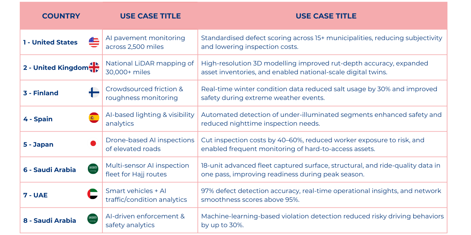
Case study 1 — United States
PennDOT modernizes pavement monitoring across 2,500 miles
Technology theme: Computer Vision
Sources: RoadBotics (2020), SmartCitiesDive (2020)
What happened: The Pennsylvania Department of Transportation partnered with RoadBotics to survey 2,500+ miles using AI-powered image analysis. Municipalities adopted standardized defect scoring across multiple jurisdictions.
Key benefits:
- Objective, comparable assessments: AI eliminated the subjectivity of manual windshield surveys.
- Rapid full-network coverage: Completion in faster than traditional methods.
- Lower inspection costs: Fewer specialized vehicles, fewer labour hours.
- Improved regional coordination: 15+ municipalities could finally compare conditions using the same scale.
- Scalable model: The program was expanded due to strong results.
Why it matters: This case demonstrates that AI can produce standardized, cost-efficient pavement assessments across multiple jurisdictions, critical for large and fragmented networks.
Case study 2 — United Kingdom
National highways uses LiDAR to map 30,000+ miles of roads
Technology theme: LiDAR & Sensor Fusion
Sources: National Highways (2021–2023), UK Department for Transport
What happened: National Highways deployed LiDAR-equipped vehicles to create high-resolution 3D models of the strategic road network.
Key benefits:
- Digital twins at national scale: Enabling advanced planning, modelling, and simulations.
- Higher inspection accuracy: Sub-millimetre geometric detail greatly improved rut-depth and surface deformation analysis.
- Reduced manual survey needs: Fewer field teams required to inventory assets or validate condition data.
- Richer asset inventory: Signs, barriers, drainage, and road furniture captured in a single LiDAR sweep.
- Foundation for future automation: Data aligns with long-term “Digital Roads” strategy.
Why it matters: The UK case shows the power of LiDAR to deliver network-wide visibility and accelerate the transition to digital asset management.
Case study 3 — Finland
Helsinki uses crowdsourced vehicle data to optimize winter maintenance
Technology theme: Crowdsourced and On-Vehicle Sensors
Sources: Vaisala (2021), European Road Safety Observatory
What happened: Helsinki used Vaisala’s vehicle-mounted sensors to collect real-time friction and road-condition data throughout winter.
Key Benefits:
- 30% reduction in salt usage: Documented improvements in cost efficiency and environmental impact.
- Improved winter safety: Real-time friction data enabled faster response to slippery conditions.
- Continuous monitoring: Instead of periodic checks, conditions were updated throughout the day.
- Optimized routing: Maintenance crews targeted the right roads at the right time.
- Low deployment cost: Leveraged existing municipal vehicles, no need for specialized fleets.
Why it matters: Finland shows how crowdsourcing can provide continuous data at minimal cost, ideal for cities with harsh climates or highly variable conditions.
Case study 4 — Spain
Basque government applies AI to improve lighting and tunnel safety
Technology theme: Safety & Operational Monitoring
Sources: ASIMOB (2022–2023), Basque Government Mobility Press Releases
What happened: The Basque Government partnered with ASIMOB to evaluate nighttime visibility and lighting performance in tunnels and interurban corridors.
Key Benefits:
- Objective lighting metrics: AI-generated indices replaced subjective nighttime inspections.
- Proactive maintenance: Under-lit sections flagged earlier, improving preventive maintenance.
- Better tunnel safety: High-risk lighting zones identified automatically.
- Reduced operational burden: Less need for nighttime field inspections, which are costly and hazardous.
- Faster intervention: Maintenance teams prioritized repairs based on severity and user impact.
Why it matters: This case highlights the wider operational benefits of AI, moving beyond pavement to safety-critical functions like lighting, tunnels, and visibility.
Case study 5 — Japan
Tokyo deploys drones and AI for structural inspections of elevated roads
Technology theme: Proactive Safety Risk Identification
Sources: Tokyo Metropolitan Government (2020–2023), Nikkei Asia, SmartCity Institute Japan
What happened: Tokyo adopted drone-based AI inspections for bridges, elevated roads, and tunnels, locations that are difficult and risky for manual inspection.
Key benefits:
- 40–60% cost reduction: Major savings from reduced scaffolding, lane closures, and manpower.
- Improved worker safety: Fewer inspectors exposed to heights, traffic, or confined spaces.
- Faster defect detection: AI identified cracking, spalling, and water intrusion more rapidly than human surveys.
- Higher inspection frequency: Inspections can be repeated more often due to lower cost and easier deployment.
- Digital condition records: Ideal for long-term monitoring and structural lifecycle management.
Why it matters: Japan proves that AI + drones are not futuristic, they are already reducing costs and improving safety in some of the world’s most complex urban networks.
Middle East use cases (details)
While much of the attention in recent years has focused on North America, Europe and Asia, the Middle East is emerging as a fast-moving adoption region for AI-enabled road monitoring solutions. With vast networks, severe climate conditions (sand, heat, shifting loads) and major infrastructure programmes underway, authorities are using AI to leap-frog legacy processes and meet ambitious national visions for mobility. The following case studies illustrate how these deployments are taking shape, and what benefits they are delivering.
Case sudy 6 — Saudi Arabia
Roads General Authority (RGA) launches an 18-unit AI-powered inspection fleet ahead of pilgrimage season
Technology theme: Multi-sensor inspection fleet (surface scanners, IRI measurement, skid resistance)
Source: Middle East AI News; HSEReview (June 2025).
What happened: The Saudi Roads General Authority activated a fleet of 18 high-tech inspection vehicles, each equipped with multiple cutting-edge technologies, including surface damage scanners, laser units for International Roughness Index (IRI) measurement, skid resistance testers, radar for pavement layer thickness, and deflection measurement systems. The deployment was timed ahead of the Hajj season (when traffic peaks on pilgrim routes) to enhance safety and network resilience.
Key benefits:
- The multi-sensor fleet enables comprehensive condition monitoring across critical corridors, capturing surface, structure, and ride-quality data in one pass.
- Accelerated inspection of heavy-use routes during the high-risk period (Hajj) helps ensure safety and reliability when it matters most.
- By deploying advanced sensors, the authority reduces reliance on separate specialist surveys, thereby optimizing resource use.
- The data collected supports network-wide prioritisation of maintenance and rehabilitation in a region where conditions (climate, heavy loads) accelerate deterioration.
Why it matters for the region: With Saudi Arabia’s rapid infrastructure expansion and national targets under Saudi Vision 2030, deploying AI-enabled inspection fleets shows a strategic shift away from reactive maintenance toward data-driven, network-wide asset management. The approach is tailored to the extreme operating context of the region.
Case study 7 — United Arab Emirates (Dubai)
Roads and Transport Authority (RTA) uses smart vehicles and driver-school monitoring to raise inspection frequency and oversight
Technology theme: Smart vehicle inspection + traffic and road condition analytics
Sources: Gulf News (Aug 2025); WAM/Media Office (Aug 2025).
What happened: In Dubai, the RTA introduced smart inspection vehicles equipped with laser, infrared, and high-resolution cameras that detect multiple types of pavement defects, including 14 distinct asphalt distress categories, and measure ride quality via IRI. Separately, the Authority launched a “Data Drive – Clear Guide” AI-powered platform that analyses historical traffic, detects recurring patterns, and assesses road conditions in real time.
Key benefits:
- Smart vehicles achieved high defect detection accuracy (quoted at approximately 97% compared to human surveys) across key urban corridors.
- Real-time condition analytics through the AI platform enable faster decision-making, moving from weeks of manual analysis to instant insight.
- Improved network smoothness: Dubai reported a Pavement Quality Index of ~95% and rideability score ~97%.
The dual traffic/pavement monitoring approach supports both asset condition and operational performance, an integrated view highly relevant in high-growth urban environments.
Why it matters for the region: Cities such as Dubai face intense growth, urbanisation and climate stress (high temperatures, heavy traffic). The combination of high-frequency condition monitoring and traffic/flow analytics positions the RTA to maintain world-class infrastructure while scaling. Dubai sets a benchmark for other Gulf cities.
Case study 8 — Saudi Arabia (Traffic/Operational AI)
AI for traffic safety, congestion
Technology theme: Operational monitoring, rather than purely pavement condition
Sources: Arab News (Feb 2025) on the “Saher” system in Saudi Arabia.
What happened: In Saudi Arabia, the Saher automated traffic enforcement system uses machine learning and camera networks to analyse driver behavior (speeding, seat-belt use, red-light running). Studies show violation reductions of up to 30% in some cities.
Key benefits:
- Reduced accident risk and improved traffic safety outcomes through continuous monitoring of driver behavior and infrastructure performance.
Why it matters for the region: While pavement condition is critical, many Gulf authorities also face major operational challenges: high vehicle penetration, extreme weather, large volumes of transit traffic (pilgrims, tourists), and 24/7 economic demands. Integrated AI for traffic and infrastructure monitoring helps manage risk across both condition and operations.
Practical takeaways
Taken together, these technologies directly address the inherent weaknesses of traditional monitoring. Automated defect detection removes subjectivity, and sensors mounted on existing vehicle fleets allow for high-frequency, often daily, condition updates instead of infrequent surveys. Costs fall as agencies rely less on specialized inspection vehicles and more on modular, scalable tools such as smartphones, on-board sensors, and AI-enabled cameras. Most importantly, early detection empowers agencies to intervene before defects escalate, ultimately extending pavement life, reducing lifecycle costs, and strengthening overall network safety.
What sets AI-enabled monitoring apart is its ability to reconcile limited resources with rising performance expectations. These systems deliver standardized, repeatable assessments across entire networks and integrate multiple data streams into unified dashboards. The outcome is monitoring that is more accurate, more efficient, and, crucially, more transparent and defensible for regulators, auditors, and the public.
Conclusion
AI is fundamentally redefining how road networks are assessed and managed. From computer vision and LiDAR mapping to crowdsourced acceleration data and lighting-performance analytics, these tools provide objective and continuous insight into assets that were historically expensive and difficult to monitor. As agencies transition from reactive fixes to predictive and risk-based maintenance, AI becomes not just an efficiency tool, but an integral part of modern infrastructure governance.
International providers such as Applus+, Ouster, Vaisala, Blyncsy, SmartCone, Invision AI, and Iteris, together with emerging innovators like ASIMOB, demonstrate the breadth and maturity of the solutions now available. For rapidly growing regions such as the Middle East, where networks are expanding quickly and environmental conditions are demanding, embracing AI-enabled monitoring is no longer optional. It is a strategic imperative.
By systematically integrating these technologies into asset management frameworks, road authorities can achieve a step change in safety, transparency, and sustainability, laying the foundation for the next generation of intelligent, resilient transport infrastructure.
About the authors

Gianluigi Coniglio
Civil Engineer with an MSc in Transportation Engineering and an MBA in International Project Management. He has over 10 years of experience in transport infrastructure and mobility projects, with expertise in highway systems, transport planning, project management, and financial analysis. Experienced in both public and private sectors. Manager at ALG.

Cesar Valero
Civil Engineer with an MSc and an MBA. Specialist in transport infrastructure with over 30 years of experience in highways, urban mobility, and rail. Experienced in both public and private sectors, focusing on sustainable transportation, transaction advisory, strategic development, and feasibility studies. Partner at ALG.


