
Within the space sector, Earth observation focuses on gathering information about Earth's parameters through satellites equipped with advanced sensors that capture data across different electromagnetic spectra. These systems not only provide visible images, but also infrared, radar, and multispectral information that reveals patterns and changes invisible to the human eye.
Given the intrinsic characteristics of satellites, which orbit the Earth at regular intervals, they are well-suited to monitoring large areas in a short period of time, allowing changes and patterns in a range of physical and environmental parameters to be identified. Once processed, EO data can be assimilated into complex models to produce new data and information (e.g., forecasts, behavioral analyses, climate projections, etc.), and complemented with in situ measurements that can lead to applications for the provision of services to users.
Earth observation from space has evolved from being a tool exclusively used by governments and space agencies to becoming a key driver of digital transformation for industries around the world. This revolution is based on the ability to convert vast amounts of satellite data into practical, actionable information, transforming the way companies make strategic and operational decisions.
The value chain of an Earth observation system consists of three main segments: upstream, dedicated to the provision of technology; downstream, dedicated to the exploitation of satellite information; and end users, who benefit from the value provided by EO.
These segments are shown in the following figure.
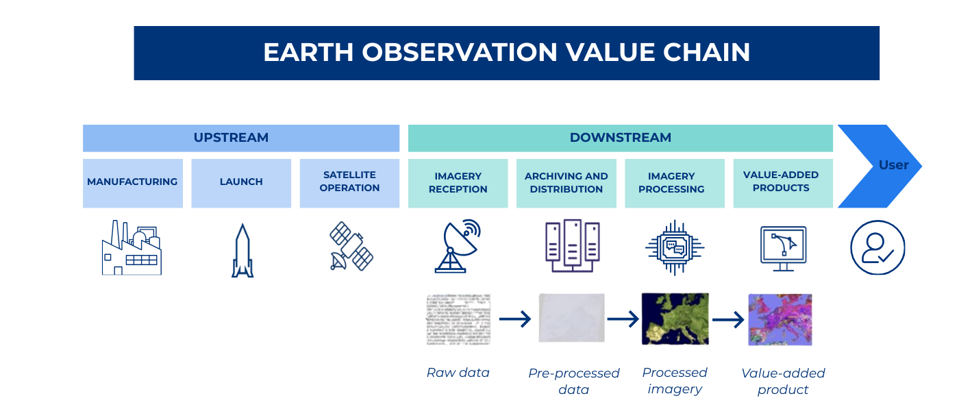
It is the downstream segment that has the greatest potential for development, taking advantage of the growing opportunities in the sector, with more than 8,000 operational satellites orbiting Earth, collecting more information than ever before. The possibility of offering this processed, user-oriented information through accessible means has led to the creation of a huge ecosystem of companies and start-ups that have launched into the development of applications to generate value-added services
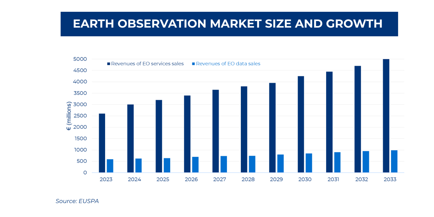
This context has led to very high growth in the sector in recent years. EUSPA estimates that the Earth observation market will exceed €3.5 billion in 2025, including both data provision and services. This market will grow to nearly €6 billion by 2033.
Market expansion is based on several key factors:
- Technological advances: Improvements in image resolution, with commercial satellites now capable of providing images with a resolution of up to 30 centimeters
- Cost reduction: The miniaturization of satellites and the development of small satellite constellations has significantly reduced operating costs
- Democratisation of access: Cloud platforms and APIs have facilitated access to satellite data for businesses of all sizes
- AI integration: The application of machine learning and computer vision has automated image analysis, reducing processing times and improving accuracy
The applications of these data and products derived from satellite imagery are highly varied and applicable to a wide range of industries, including urban planning, agriculture, environmental management, border security, maritime surveillance, and disaster management support.
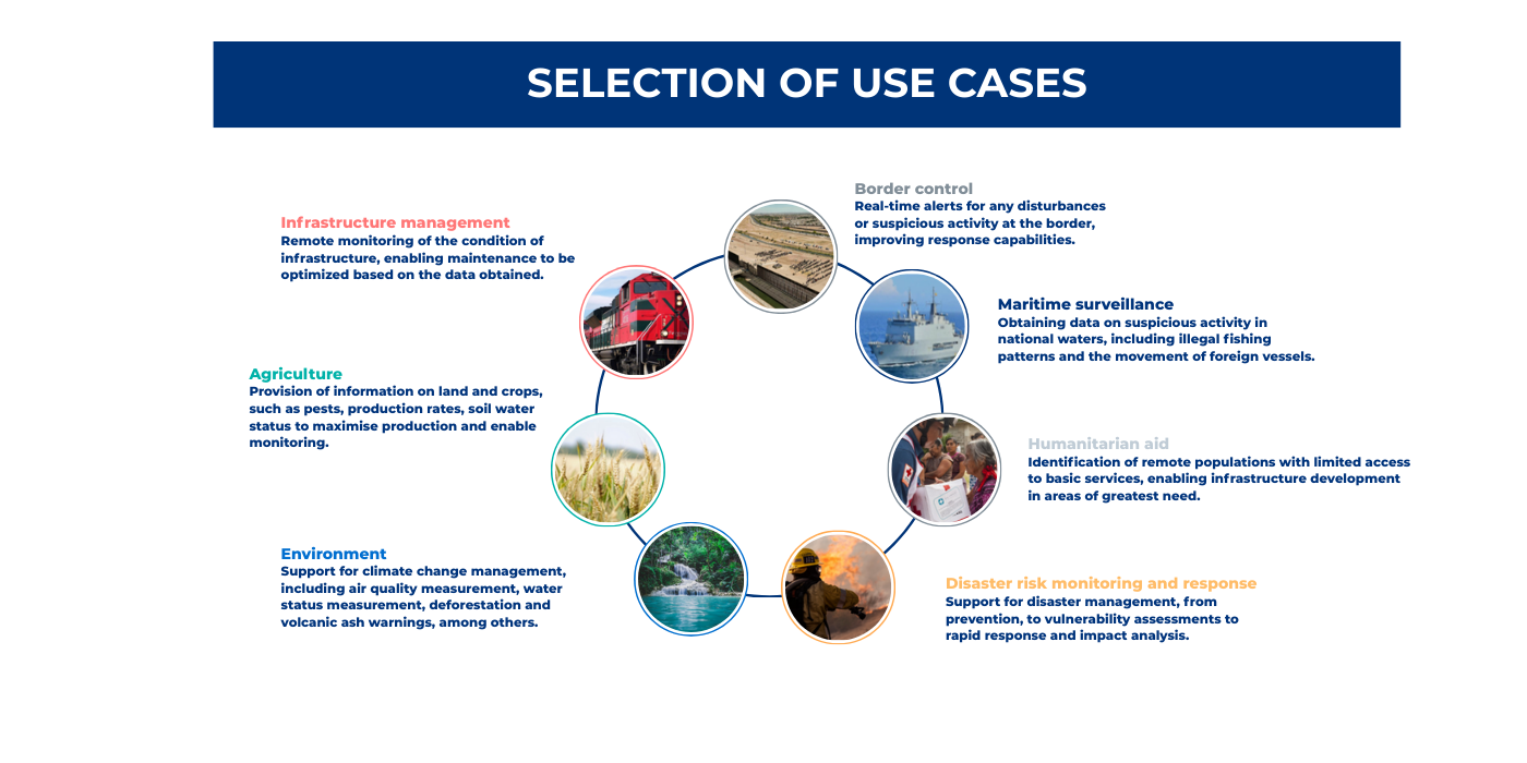
Below are details of specific use cases:
The transformation of satellite imagery into actionable intelligence represents one of the most significant technological revolutions of our era. With Europe leading the way through the Copernicus programme and a growing ecosystem of innovative companies, the sector is positioned for continued growth and expansion into new applications.
The convergence of abundant satellite data, advanced processing capabilities, and growing demand for geospatial intelligence creates an environment conducive to continuous innovation. Organisations that adopt these technologies early will be better positioned to take advantage of the opportunities of the 21st century digital economy.
ALG brings extensive experience in conducting comprehensive feasibility studies, needs assessments, and requirements gathering to define and prioritize high-value satellite imagery use cases for both public and private sector clients, specifically on Transport and Infrastructure domains. By closely engaging with stakeholders and aligning technical capabilities with operational and strategic objectives, ALG can support organizations in identifying where satellite data can deliver the greatest impact to their business.
About the authors


Mario Cano
BSc in Aeronautical Engineering, MSc in Astronautics and Space Engineering, and MSc in Aerospace Engineering. Executive MBA from IESE. Senior Engagement Manager at ALG specializing in ATM and Space.


 system")


